Severe Thunderstorm Outbreak Targets Midwest with Tornado Risk on Wednesday
Qwenews.com – As the nation braces for a significant weather event, a severe thunderstorm outbreak is poised to target the Midwest on Wednesday, bringing with it the potential for intense tornadoes and other hazardous conditions. This system, more powerful than average for this time of year, is expected to generate a wide range of severe weather phenomena, including damaging wind gusts, large hail, and tornadoes that could impact multiple states. The forecast underscores a complex and evolving storm scenario, with meteorologists warning that the region could face a heightened risk compared to typical June conditions. The outbreak follows a multi-day storm event that already saw over 1,500 reports of wind, hail, and tornadoes across the central U.S., setting the stage for another round of severe weather.
Forecast Details: High-Risk Zones and Storm Intensity
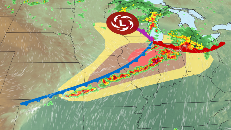
The severe thunderstorm outbreak to target the Midwest is anticipated to peak in intensity during the late afternoon, though some strong systems may develop earlier in the day over parts of southern Minnesota and eastern Iowa. As the day progresses, the main danger will shift eastward, concentrating from Missouri to Indiana, with the highest risk levels reported in central and northern Illinois and northwestern Indiana. Meteorologists have classified the risk as a Level 4 out of 5 for these areas, while the rest of the Midwest faces a Level 3 risk. This means that supercell thunderstorms, which are known for their capacity to spawn tornadoes, are expected to traverse high-risk zones, creating a potential for multiple touchdowns.
Climate Change and the Role of Unusually Robust Storm Systems
Experts are noting that the severity of the storm system may be influenced by broader climate trends. The unusually robust nature of this weather event is linked to increased atmospheric moisture and energy, factors that have become more pronounced in recent years due to climate change. These conditions provide the perfect environment for the development of powerful thunderstorms, which can persist for longer durations and produce stronger tornadoes than usual. The connection between climate patterns and the intensity of such outbreaks is a key point of discussion among meteorologists, who are highlighting how rising global temperatures may be altering the frequency and strength of severe weather events in the Midwest.
While supercells are the primary source of tornadoes in the region, the severe thunderstorm outbreak to target the Midwest may also bring about twisters from other storm systems. This could mean that elevated risk areas might experience tornadoes reaching EF3 strength or higher, with the potential to travel significant distances. Although these extreme scenarios aren’t guaranteed, the likelihood is greater than average, thanks to the powerful storm system creating ideal conditions for tornado formation. The combination of warm, moist air from the Gulf of Mexico and cooler air from the north is expected to fuel the development of these dangerous storms, making Wednesday a critical day for weather preparedness across the Midwest.
Explore CNN Weather for iPhone
The severe thunderstorm outbreak to target the Midwest is expected to extend into the early hours of Thursday, though the primary threat will diminish as the system moves eastward. By late Wednesday, damaging wind gusts exceeding 75 mph are projected to dominate, with storms potentially merging into organized lines starting in eastern Kansas and spreading westward toward western Ohio. Overnight, these systems will continue to move southeast, gradually easing as the storm activity transitions eastward. The persistence of this weather pattern raises concerns about the potential for prolonged severe weather, which could impact travel, agriculture, and daily activities for residents across the region.
As the Midwest prepares for the severe thunderstorm outbreak to target the area, officials are urging communities to stay vigilant and take necessary precautions. Emergency management teams are coordinating with meteorologists to issue timely alerts and ensure public safety. The storm’s trajectory and intensity will be closely monitored, with updates provided throughout the day to keep residents informed. In addition to tornadoes, the outbreak may lead to flash flooding, downed trees, and power outages, all of which require careful planning and response. The extended duration of the storm system means that the effects of the severe weather could last into Thursday, emphasizing the need for continued preparedness.