
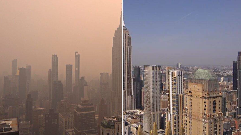
Before and after images: Wildfire smoke casts skylines in dystopian haze
Qwenews.com – Before and after images have become striking visual evidence of the transformative power of wildfire smoke, now blanketing the skies over the Midwestern and Northeastern United States. The phenomenon, driven by persistent wildfires in Canada, has created a surreal atmosphere where once-clear horizons are replaced by thick, brown-orange clouds. These images, captured across multiple regions, highlight the dramatic shift in air quality and the unsettling aesthetic of a landscape altered by climate-driven events.
The Dystopian Haze Across Major Cities
As the smoke from Canadian wildfires expanded its reach, cities like Chicago and New York became focal points of the environmental crisis. On Thursday, Chicago’s skyline was engulfed in a haze that reduced visibility and made the air feel oppressive, while New York grappled with deteriorating air quality since Wednesday. Washington, D.C., experienced a sudden surge in haze on Friday, casting a heavy shadow over iconic landmarks. Central Pennsylvania, Minneapolis, and Grand Rapids also reported significant changes, with the sky’s color shifting from blue to a murky brown-orange tint. These before and after visuals offer a stark contrast between the region’s typical skies and the current dystopian conditions.
Regional Disruption and Atmospheric Changes
The spread of wildfire smoke has disrupted air quality metrics across the Midwest and Northeast, with several cities recording hazardous levels of particulate matter. In Chicago, the smoke’s impact was compounded by stagnant air patterns, which trapped pollutants near the ground. Meanwhile, New York’s situation was influenced by a combination of wind direction and humidity, leading to a prolonged presence of the haze. Washington, D.C., faced a unique challenge as the smoke settled in the region’s lower atmosphere, creating an almost apocalyptic visual effect. Comparative before and after images, such as those of Central Pennsylvania’s skies, underscore the rapid and pervasive changes affecting urban and rural areas alike.
Residents in affected regions have shared vivid accounts of the haze’s impact, describing the skies as if they were “swallowed by a giant blanket.” In Minneapolis, the smoke obscured the skyline entirely, turning the city into a surreal, amber-tinged environment. Grand Rapids, Michigan, saw a similar transformation, with the once-familiar blue skies giving way to a brownish hue. These before and after images serve not only as a record of the current situation but also as a warning of the broader implications of climate change, including increased frequency of such atmospheric disruptions.
“The contrast between the pristine skies we once took for granted and the current haze is a powerful reminder of how interconnected our ecosystems are,” said Dr. Emily Carter, an atmospheric scientist at the National Oceanic and Atmospheric Administration (NOAA). “Before and after images help us visualize the scale of the problem and track its progression over time.”
Public health concerns have surged as the smoke’s presence intensifies. Health officials warn that prolonged exposure to the haze can lead to respiratory issues, particularly for vulnerable populations like children and the elderly. The Environmental Protection Agency (EPA) has issued air quality alerts for several states, emphasizing the need for precautionary measures. Before and after images of the affected areas also highlight the environmental cost, with vegetation and water sources showing signs of stress from the particulate matter. This visual documentation plays a critical role in raising awareness about the urgent need for climate resilience strategies.
As the situation evolves, before and after images will continue to be essential tools for understanding the environmental and societal impacts of the smoke. The Midwest and Northeast are now part of a larger narrative about how climate change is reshaping the natural world, with wildfires in one region triggering visible changes thousands of miles away. These images, combined with ongoing data tracking, offer a comprehensive view of the crisis and its long-term consequences, reinforcing the importance of monitoring and mitigating such events in the future.