
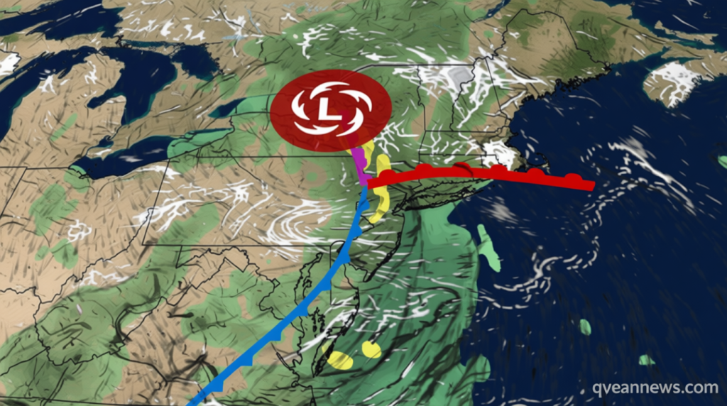
Unprecedented Summer Storm Brings Flash Flood Danger to Northeast
Qwenews.com – An exceptionally powerful weather system is currently moving through the Northeast, placing the New York City metropolitan region under heightened alert for potential flash flooding. Residents should brace for what could amount to an entire month’s precipitation falling within just several days. This soaking weather pattern originates from an energy pocket that has already ignited severe thunderstorms across portions of the Great Lakes and Ohio Valley on Monday.
Storm Characteristics and Timeline
While powerful wind gusts represent the primary hazard—capable of toppling trees and disrupting electrical service—isolated tornadoes remain a possibility. One particularly devastating tornado struck northeast Wisconsin on Monday afternoon. According to CNN Weather, the system will transition into the Northeast on Tuesday, where it will both strengthen and decelerate considerably.
Forecasters anticipate the storm will remain stationary over portions of the region through at least Thursday, releasing excessive rainfall. When positioned over central New York on Wednesday, the system’s intensity will rival what meteorologists typically observe during October, November, or December rather than late July. Summer storms generally exhibit less power than their winter counterparts because the jet stream contributes less intensification energy.
Simultaneously, this weather pattern is drawing upon moisture-laden air corridors from both the Atlantic Ocean and the Gulf of Mexico. Water vapor concentrations within this air mass will surpass normal midsummer humidity levels significantly. These contrasting atmospheric conditions will generate repeated cycles of intense rain and thunderstorms throughout the Northeast.
Monday’s Precursor Events
Northern New Jersey experienced an ominous preview on Monday before the primary storm system arrived. Radar data indicates a slow-moving thunderstorm deposited more than 3 inches of precipitation near Glen Rock and Ridgewood, creating flooding across highways and streets in portions of Bergen and Passaic counties. Video footage captured in Glen Rock revealed a BMW almost completely submerged in water.
Two occupants managed to escape the vehicle before emergency responders arrived, though water depth initially prevented a tow truck from reaching the car. Multiple water rescue operations occurred around Glen Rock, Hawthorne, and Fair Lawn, New Jersey. This flooding represented merely a preliminary event, as Monday’s inundation stemmed from a localized thunderstorm preceding the larger system expected to generate broader flood concerns beginning Tuesday.
Regional Flood Risk Assessment
Parts of the region already exhibit saturated ground conditions, making them increasingly susceptible to additional flooding. The New York Tri-state area, extending from northern New Jersey through western Connecticut, faces the greatest risk of flooding rainfall on Tuesday and Tuesday evening, though a localized threat encompasses most other Northeastern areas.
Rainfall from eastern New York to Pennsylvania during morning hours will likely be followed by additional precipitation episodes in the afternoon and evening. The most intense storms may generate rainfall rates reaching 2 inches per hour. Urban environments and areas with inadequate drainage systems will experience the most significant flooding concerns, with some regions potentially facing impacts comparable to previous occurrences across the United States this month, including New York City on July 18, according to the National Weather Service.
Flash flooding ranks among the deadliest weather hazards, particularly within urban settings. Nearly five years ago, dozens perished in the Northeast when Hurricane Ida deposited 7 to 10 inches of rain across a similar corridor currently facing threat.
Extended Forecast
July has now become flash flood emergency season. Further south, severe thunderstorms threaten areas from Washington, DC to North Carolina on Tuesday, with wind damage representing the primary concern for any intensifying storms.
The most extensive flash flood threat will gradually shift northward on Wednesday into southern New England, encompassing Boston and Hartford, while New York City will maintain its risk level. Downpours will likely continue across this region as the day progresses. Flash flooding could develop as one or more narrow bands of heavy rain move northeastward through the afternoon, with new storms potentially forming behind this area.
The National Weather Service in Boston indicated that at least scattered flash flooding impacts are possible, particularly in urban and poorly drained areas. Travel delays are anticipated at airports and on roadways throughout the region. Pockets of heavy rainfall may persist in parts of the Northeast on Thursday, though specific flooding concerns remain difficult to pinpoint at this stage. Much of the Northeast flood threat area will accumulate 1 to 4 inches of rainfall through Thursday, with local areas potentially receiving 6 inches or more, and higher amounts possible in certain locations.