
Lowell Swings North: Hawaii Faces Its Third Storm in Three Weeks as El Niño Fuels an Unusually Violent Pacific Season
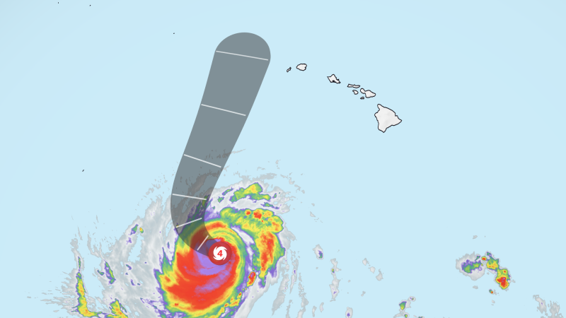
Qwenews.com – The western Hawaiian islands of Kauai and Niihau now sit under tropical storm warnings as Hurricane Lowell executes a sharp right turn that will bring its outer bands within striking distance of the archipelago. The storm, currently a Category 3 with sustained winds of 120 mph, is moving north at roughly 6 mph and is forecast to weaken to near Category 2 strength by the time it reaches its closest point to the islands. Its center is expected to pass approximately 110 miles west of Niihau and 150 miles west of Kauai between late Monday night and Tuesday morning — close enough to deliver dangerous surf and torrential rain, yet far enough offshore to spare the islands a direct hurricane-force landfall.
The Meteorological Mechanism Behind the Turn
For several days, Lowell was pinned beneath a broad, weak upper-level ridge of high pressure that effectively acted as a ceiling over the islands, channeling the storm westward and keeping it south of Hawaii. That configuration began to collapse over the weekend when a trough of cold air descended from the north Pacific and collided with a nearby low-pressure area. Once the ridge lost its grip, the storm was free to veer north, and it is now scraping along the western edge of the Hawaiian chain.
The pattern draws an uncomfortable parallel to 1992’s Hurricane Iniki, which struck Kauai as a Category 4 and remains the most destructive storm in Hawaiian history. This time, forecasters expect Lowell to remain sufficiently offshore to avoid that fate, though the comparison underscores how quickly a Pacific system can shift from a distant threat to a direct hit.
What the Islands Can Expect
Winds exceeding 39 mph are anticipated within the next 36 hours, though the strongest sustained winds will stay confined to the western islands. Terrain effects, however, will amplify the threat: mountain peaks and steep slopes across the archipelago can accelerate airflow to hurricane-force gusts even when the storm’s core remains offshore.
Rainfall totals are the primary hazard. The National Hurricane Center projects 6 to 8 inches of rain for Kauai, Niihau, and the Big Island, with isolated pockets exceeding 12 inches. Oahu, Molokai, Lanai, and Maui are forecast to receive 2 to 4 inches on average, though elevated terrain on those islands could accumulate up to 8 inches. The hurricane center has specifically warned of
“significant flash flooding and mudslides,”
particularly in steep, already-saturated terrain where weeks of above-normal rainfall have left soils vulnerable.
Surf conditions are already deteriorating. A high surf advisory is in effect for south-facing shores statewide, and the National Weather Service in Honolulu reports waves reaching up to 14 feet through Sunday afternoon. Coastal erosion, rip currents, and overtopping at low-lying beaches are expected to intensify as the storm’s swell field tightens.
Statewide Emergency Response
Hawaii Governor Josh Green declared a state of emergency for the entire state on Thursday, a move that unlocks state resources and authorizes activation of Hawaii National Guard units. Six high-water vehicles are being staged on Kauai to support evacuation and rescue operations in areas where standard vehicles cannot operate. The declaration also streamlines coordination between county emergency managers, utility companies, and federal agencies should infrastructure damage occur.
El Niño and a Broader Seasonal Context
Lowell is the third storm to target Hawaii in just over three weeks, a pace made possible by El Niño conditions that are warming central Pacific sea-surface temperatures and suppressing the upper-level wind shear that normally tears storms apart. Layered atop the long-term ocean warming driven by climate change, these factors have created an unusually fertile environment for tropical cyclones in the central basin.
The National Oceanic and Atmospheric Administration has projected an above-average central Pacific season, with five to 13 tropical cyclones expected. Lowell’s fluctuation between hurricane categories as it undergoes the normal intensity cycling of a major storm is a reminder that these systems can strengthen and weaken rapidly, making short-term forecast uncertainty a persistent challenge for residents and emergency planners alike.
For island residents, the practical guidance is straightforward: monitor official channels for updated warnings, secure or anchor outdoor objects, ensure emergency kits are stocked, and avoid low-lying drainage areas and coastal zones during periods of peak rainfall and surf. The storm’s offshore track reduces the probability of catastrophic wind damage, but the combination of extreme rainfall, steep topography, and already-elevated ground saturation means that flooding and landslide risks remain severe across all eight islands through at least Tuesday.
Related Reading
Frequently Asked Questions
What is Hurricane Lowell makes final turn toward?
Hurricane Lowell makes final turn toward is the main topic of this guide. The article explains the context, practical details, and next steps readers should understand.
Why does Hurricane Lowell makes final turn toward matter?
Hurricane Lowell makes final turn toward matters because readers are looking for a useful answer, not just a short summary. Good content should match search intent and help them decide what to do next.