
Colombia Reels from Devastating 7.4 Magnitude Earthquake
Qwenews.com – Western Colombia faced unprecedented destruction on Monday when a powerful seismic event registered 7.4 on the magnitude scale. The tremor claimed numerous lives and left thousands of structures either destroyed or severely compromised. According to the US Geological Survey, this represents the most intense earthquake to originate within the Andean nation since at least 1990.
Location and Regional Impact
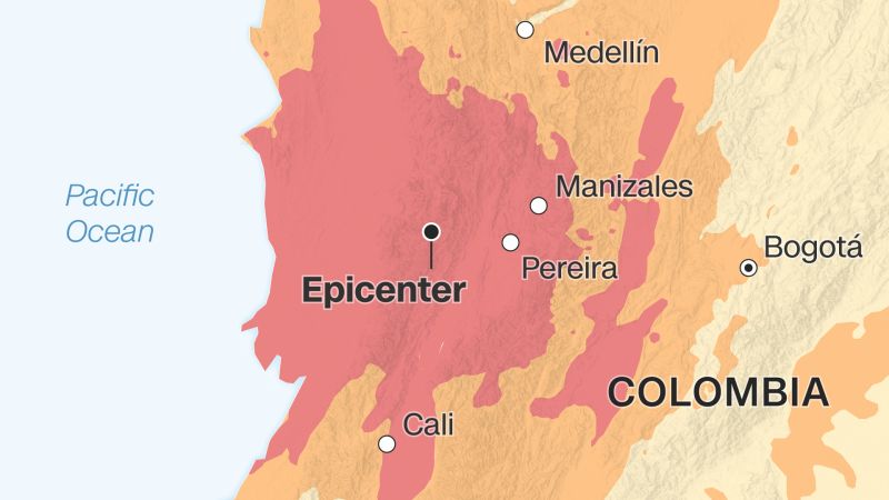
The epicenter rested in San José del Palmar, situated within Chocó’s northwestern department. This location sits approximately 240 kilometers—or 149 miles—west of the capital city of Bogotá, where residents clearly felt the shaking. Neighboring Venezuela also experienced noticeable tremors, adding to challenges the country already faces following a series of destructive earthquakes earlier this summer.
The powerful quake struck directly through South America’s coffee-growing heartland, pushing communities into a national disaster emergency. Cities like Cali and Pereira suffered particularly heavy damage, with many buildings essentially leveled or rendered unsafe.
Dramatic Scenes Captured on Video
Footage from Pereira captured terrified residents huddling in intersection centers as surrounding structures swayed violently. One harrowing sequence shows people watching in horror before sprinting away as a nearby building collapsed into the street, sending clouds of dust and debris toward fleeing crowds.
Another viral social media video documented the University Hospital of Cali’s building crumbling to the ground during the shaking. Meanwhile, CNN geolocated footage from Manizales revealed two women desperately running through the city center as portions of a building began falling around them. Both women struggled to maintain their balance, with one leaping to safety while passersby assisted the other as the earthquake continued rattling the area.
Geological Context
While most earthquakes occur near tectonic plate boundaries, they occasionally happen within continental interiors according to the USGS. Julio Fierro Morales, who directs the Colombian Geological Service, explained that western Colombia occupies a subduction zone where one tectonic plate slides beneath another.
“For this reason, this region has experienced earthquakes of considerable magnitude throughout its history,” Fierro Morales stated. “Among the historical precedents is the earthquake that occurred on November 23, 1979, with a magnitude of 7.2.”
Earthquakes like Monday’s are classified using magnitude scales. A reading of 7.4 falls into the “major” category, indicating significant damage is expected. CNN’s Gonzalo Zegarra, Max Saltman, Sana Noor Haq, Magdalena Vitores Moreno and Lauren Said-Moorhouse contributed reporting.
Related Reading
Frequently Asked Questions
What is A visual guide to the Colombia?
A visual guide to the Colombia is the main topic of this guide. The article explains the context, practical details, and next steps readers should understand.
Why does A visual guide to the Colombia matter?
A visual guide to the Colombia matters because readers are looking for a useful answer, not just a short summary. Good content should match search intent and help them decide what to do next.