
Tropical Storm Bertha Moves Inland, Threatening Eastern Floods
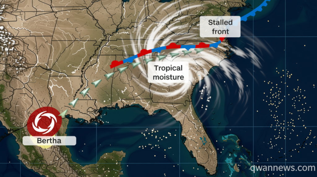
Qwenews.com – Tropical Storm Bertha moves inland over the Texas-Louisiana border, but the heaviest impacts may not be where the storm currently sits. While the system maintains tropical storm status with sustained winds near 45 mph, its moisture is being drawn into a stationary cold front that stretches across the Southeast. This atmospheric setup is creating a significant flood threat for areas hundreds of miles from the storm’s center, particularly in the Carolinas, northern Georgia, and Alabama. Residents in these regions should prepare for prolonged rainfall that could saturate already wet ground.
North Carolina has seen remarkable precipitation totals recently, with some locations receiving a full month’s worth of rain in just a few days. Flash flood warnings were active Wednesday night for the Greensboro and Winston-Salem areas, where storms dumped up to 6 inches of rain within a 12-hour window. Despite these substantial totals, major flooding has been avoided so far. The steady, extended nature of the rainfall has actually helped ease drought concerns in parts of the state that have been struggling with dry conditions.
Widespread Warnings Across Multiple States
Thursday morning brought an expanded network of flash flood warnings covering southeast Virginia, eastern North Carolina, and eastern Tennessee. Transportation officials reported that Interstate 40 experienced a brief closure northwest of Durham before reopening to traffic. In Tennessee, storms north of Knoxville produced flash flooding Wednesday morning after accumulating approximately 5 inches of precipitation over a short period. These rapid rainfall events are testing drainage systems across the region.
Urban centers face heightened vulnerability as Thursday afternoon thunderstorms develop. Rainfall rates could approach 2 inches per hour in some areas, which can quickly overwhelm city drainage infrastructure. Atlanta, Birmingham, and Charlotte are among the major metropolitan areas being monitored for potential urban flooding. Emergency management officials in these cities have been preparing contingency plans for rapid response if water levels rise quickly.
Bertha’s Future Path and Rainfall Distribution
The National Weather Service projects that Bertha will maintain tropical storm intensity through Thursday evening before gradually weakening. The storm’s uneven structure means most of its activity remains concentrated over the Gulf region. This positioning indicates that any remaining strong wind gusts will primarily impact the upper Texas Coast and southwest Louisiana. Meanwhile, the majority of Bertha’s rainfall will reach South Texas, where dry soil conditions should help minimize flash flooding despite the heavy precipitation expected.
A tropical storm warning currently covers the area from the upper Texas Coast, including Galveston, extending to south-central Louisiana where tropical storm conditions are anticipated Thursday. Farther south, portions of the middle Texas Gulf Coast and South Texas could receive between 2 and 4 inches of rain, with isolated locations potentially seeing up to 6 inches through Thursday night. These totals come after a relatively quiet period for the region.
Seasonal Context and Extended Threat Timeline
As the Atlantic hurricane season’s second named storm, Bertha arrives during a comparatively quiet period for tropical activity. El Niño’s strengthening influence has suppressed development across parts of the basin compared to recent years. The storm’s moisture began connecting with a slow-moving front over the Southeast and southern Virginia on Wednesday, establishing the foundation for the current flood threat that extends well beyond the storm’s immediate path.
A Level 2 of 4 risk for flooding rain extends from the Carolinas westward to northern Alabama through Friday morning. The threat persists into Friday, with the elevated risk stretching from coastal North Carolina through South Carolina, northern Georgia, and into northeast Alabama. While the Carolinas desperately need rainfall to alleviate drought conditions, repeated precipitation over the same areas could rapidly escalate into dangerous flash flooding scenarios. Residents are encouraged to monitor local forecasts and be prepared for changing conditions through the weekend.