
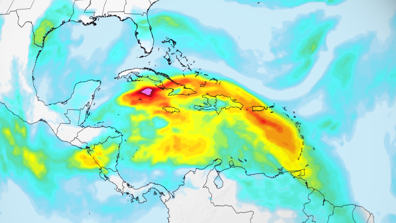
Signs of El Niño are already appearing in the Atlantic
Qwenews.com – Signs of El Niño are already influencing the Atlantic hurricane season, which has started with unusually low storm activity. While the first few weeks have seen minimal tropical development, climate experts are pointing to the phenomenon as a key factor behind the subdued beginning. This marks the quietest opening to the season since 2009, with the first named storm, Trop, still far from forming. The connection between El Niño and the current atmospheric conditions has sparked renewed discussions about how the climate cycle shapes weather patterns across the globe.
Understanding El Niño and Its Climate Impact
El Niño is a natural climate cycle characterized by the warming of ocean temperatures in the equatorial Pacific, which in turn disrupts global atmospheric systems. This pattern typically lasts 12 to 18 months and can significantly alter weather patterns worldwide, from increased rainfall in South America to droughts in parts of Africa. The current El Niño was confirmed in June and is projected to strengthen further by the end of the year, potentially evolving into a historic Super El Niño. Such an event could have far-reaching consequences, including intensified wind shear and altered storm tracks in the Atlantic.
Wind shear, a critical factor in tropical storm formation, is currently dominating the Caribbean and western Atlantic regions. This phenomenon, which involves variations in wind speed or direction across different atmospheric layers, can tear apart developing systems or prevent them from forming in the first place. Signs of El Niño are already evident in these shear patterns, which have been measured at second-highest levels since 1979. The intensity of these conditions suggests a stronger-than-anticipated influence from the climate cycle, even as other factors like sea surface temperatures and trade winds play a role.
Expert Insights on El Niño’s Influence
“The presence of wind shear is one of the clearest signs of El Niño’s impact,” said Michael Lowry, a hurricane specialist with CNN affiliate WPLG-TV. According to NOAA data analyzed by Lowry, the current shear levels in the Caribbean are among the strongest on record, aligning with historical patterns associated with El Niño years. This reinforces the idea that the climate cycle is shaping the season’s trajectory in ways that are both predictable and significant.”
Matthew Rosencrans, a NOAA meteorologist, added that while El Niño isn’t the sole driver of the season’s calm, its influence is strongly correlated with the observed trends. The ongoing behavior of atmospheric systems has matched expectations for El Niño years, though definitive confirmation will require analysis after the season concludes in November. Signs of El Niño are already visible in the data, which suggests that its effects are more pronounced than initially anticipated, potentially altering the traditional dynamics of hurricane activity.
El Niño’s Broader Atmospheric Effects
El Niño’s influence extends beyond wind shear, affecting the Walker Circulation—a global atmospheric pattern that drives air movement in the Pacific and Atlantic basins. During El Niño events, warm air rises in the central Pacific, while sinking air in the western Atlantic suppresses storm formation, creating a feedback loop that limits tropical development. This process, which signs of El Niño are already influencing, is a major reason why the Atlantic has remained relatively quiet despite the peak of the season.
Levi Silvers, a research scientist at Colorado State University, emphasized that the evidence supporting El Niño’s role is growing. “We can’t be certain the current shear is directly linked to El Niño, but the data strongly supports its impact,” he noted. The alignment of atmospheric conditions with climate models suggests a consensus among experts that the climate cycle is playing a central role in shaping the season. Signs of El Niño are already apparent in these models, which predict a higher likelihood of weaker storms and fewer named systems forming in the coming months.
Revised Forecasts and Regional Implications
Most pre-season forecasts anticipated a less active hurricane season due to El Niño, but the confirmation of its presence has led to adjustments in predictions. Some models now suggest an even quieter season than initially expected, with signs of El Niño being already evident in the projected storm activity. However, this doesn’t mean the threat is entirely gone—regional risks remain, particularly in the Gulf of Mexico and the southeastern U.S. coast, where conditions could still foster organized systems.
While the current season has not yet seen a major threat, the ongoing influence of El Niño means that the atmosphere is primed for a shift in activity. Signs of El Niño are already shaping the path of storms, which may become more intense or frequent as the phenomenon strengthens. This could have implications for coastal regions, where preparedness efforts are critical. As the season progresses, the relationship between El Niño and hurricane behavior will continue to be a focal point for meteorologists and policymakers alike.